Friday, May 1, 2015
Sinkholes
Sinkholes
Sinkholes develop from both manmade and natural causes. The illustrations below show us how both occur. Areas with a limestone layer above an impervious igneous or metamorphic rock bed stone layer have a greater tendency to have sinkholes because the sedimentary limestone is susceptible to the acidic erosion of rain water which has absorbed carbon dioxide.
Naturally Occurring Sinkholes

http://dnr.mo.gov/geology/geosrv/envgeo/sinkholes.htm
Human-Made Sinkholes
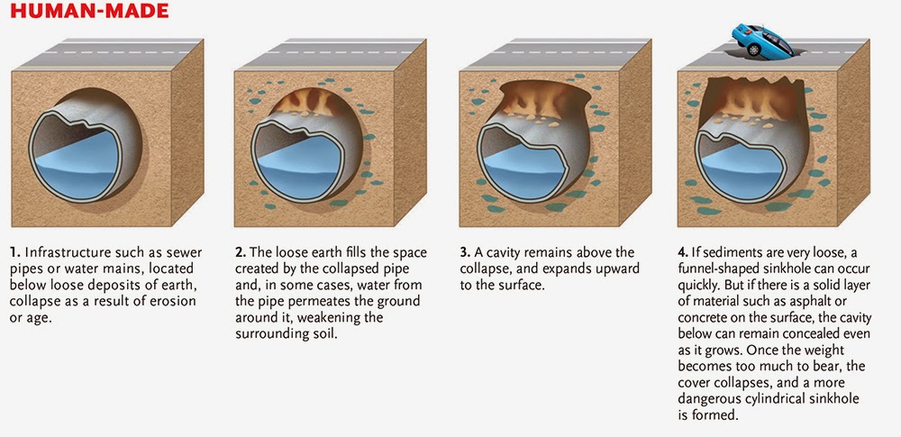
http://www.canadiangeographic.ca/magazine/jun14/how-sinkholes-form.asp
Silverman, Jacob. "How Sinkholes Work" 19 November 2008. HowStuffWorks.com. <http://science.howstuffworks.com/nature/natural-disasters/sinkhole.htm> 02 May 2015.
The Beauty of Sandstone and Sandstone Formations
Nature has a wonderful way of creating beautiful scenery that humans can only wish to imitate and can only come close in comparison. The sedimentary rock formations of sandstone are just one example of these many natural beauties. Created by erosion of other rocks and minerals, igneous and metamorphic rock, and other sedimentary rocks; these rocks form over time as pressures and temperatures compress these smaller particles into these colorfully beautiful formations.
Coyote Buttes
Found in Utah and Arizona, these sandstone formations are part of Coyote Buttes. Coyote Buttes is just a small part of Paria Canyon - Vermilion Cliffs Wilderness which is protected by the U.S. Bureau of Land Management (these photos are from their site http://www.blm.gov/az/st/en/arolrsmain/paria/coyote_buttes.html).


Arches National Park - Utah
Another location where sandstone formations leave visitors in awe is the Arches National Park in Utah. The sandstone in Arches National Park gets its bright red color from iron deposits in the sandstone. These iron deposits have been exposed to oxygen which has caused them to "rust", creating the beautiful red hues. The photos were taken from National Park Services' web site (http://www.nps.gov/media/photo/gallery.htm?id=221F3BB7-155D-451F-6738DBB434CFBF5E).


One of the arches from the park provides a beautiful addition to a photo which captures part of the Milkyway Galaxy.


This illustration from the National Park Services, shows how these arches formed over time. The following is their description of how these formations were created.
Sandstone is made of grains of sand cemented together by minerals, but not all sandstone is the same. The Entrada Sandstone was once a massive desert, full of shifting dunes of fine-grained sand. The grains are nearly spherical so, when packed together, they formed a rock that is very porous (full of tiny spaces).
In contrast, the Carmel layer just beneath the Entrada contains a mix of sand and clay. Clay particles are much smaller than sand grains; a lot of them can pack together and fill in gaps between the sand grains, making the rock denser and less porous than a purer sandstone.
Crack it into parallel lines.
Deep beneath the surface lies a thick layer of salts. Squeezed by the tons of rock above it, the salt flowed and bulged upward, creating long domes. The rock layers covering these domes were forced to crack, like the surface of freshly-baked bread, into a series of more-or-less parallel lines.
Next, add the right amount of rain.
On average, the park receives 8-10 inches (18-23 cm) of precipitation a year. That might not sound like much, but it's enough to keep the engines of erosion working 24 hours a day, 365 days a year.
Drops of rainwater soak into the porous Entrada sandstone easily and then slowly dissolve the calcite bonding the sand together – in other words, rotting the rock from the inside out. Water puddles just above the denser Carmel layer where it erodes a cavity, like food trapped between your teeth. In winter, water trapped between the two layers expands when it freezes and pries the rock apart.
If the park received too much precipitation, the sandstone could erode so quickly that arches might not have time to form. If it never rained here, the engines of erosion would stop.
Make sure your rocks don't rock & roll.
Luckily, earthquakes are rare in this area. If the ground shook often, these massive outdoor rock sculptures would splinter and collapse. The fact that over 2,000 still stand, waiting for visitors to discover them, tells us this area has been rather geologically stable for at least 50,000 years.
Lastly, pick the right time to visit. (You did.)
The rock layers visible in the park today were once buried by over a mile of other rock that had to erode first to expose what lied beneath. Visitors one million years ago might have seen an endless flat plain dotted with vegetation. Imagine a visit 100,000 years in the future, when the Entrada and Carmel layers have fully worn away. What new rock shapes might you discover then? (Source, National Park Services - http://www.nps.gov/arch/learn/nature/geologicformations.htm)
Community Gardens
Community Gardens

Community Gardens come in so many shapes and sizes but the most important thing about community gardens is the people! There are many benefits that come along with community gardening that go far beyond the delicious and healthy produce that is grown and eaten. According to the GardenDallas website (gardendallas.com) some of these benefits are:
Community Organizing

• Community gardens increase a sense of community ownership and stewardship.
• Community gardens foster the development of a community identity and spirit.
• Community gardens bring people together from a wide variety of backgrounds (age, race, culture, social class).
• Community gardens build community leaders.
• Community gardens offer a focal point for community organizing, and can lead to community-based efforts to deal with other social concerns.
Crime Prevention

• Community gardens provide opportunities to meet neighbors.
• Community gardens build block clubs (neighborhood associations).
• Community gardens increase eyes on the street.
• Community gardening is recognized by the many police departments as an effective community crime prevention strategy.
Cultural Opportunities

• Community gardens offer unique opportunities for new immigrants (who tend to be concentrated in low-income urban communities) to:
- Produce traditional crops otherwise unavailable locally,
- Take advantage of the experience of elders to produce a significant amount of food for the household,
- Provide inter-generational exposure to cultural traditions,
- Offer a cultural exchange with other gardeners,
- Learn about block clubs, neighborhood groups, and other community information.
• Community gardens offer neighborhoods an access point to non-English speaking communities.
• Community gardens allow people from diverse backgrounds to work side-by-side on common goals without speaking the same language.
Youth

Community gardens offer unique opportunities to teach youth about:
• Where food comes from
• Practical math skills
• Basic business principles
• The importance of community and stewardship
• Issues of environmental sustainability
• Job and life skills
And,

• Community gardening is a healthy, inexpensive activity for youth that can bring them closer to nature, and allow them to interact with each other in a socially meaningful and physically productive way.
Food Production

• Many community gardeners, especially those from immigrant communities, take advantage of food production in community gardens to provide a significant source of food and/or income.
• Community gardens allow families and individuals without land of their own the opportunity to produce food.
• Community gardens provide access to nutritionally rich foods that may otherwise be unavailable to low-income families and individuals.
• Urban agriculture is 3-5 times more productive per acre than traditional large-scale farming!
• Community gardens donate thousands of pounds of fresh produce to food pantries and involve people in processes that provide food security and alleviate hunger.
Health

• Studies have shown that community gardeners and their children eat healthier diets than do non-gardening families.
• Eating locally produced food reduces asthma rates, because children are able to consume manageable amounts of local pollen and develop immunities.
• Exposure to green space reduces stress and increases a sense of wellness and belonging.
• Increasing the consumption of fresh local produce is one of the best ways to address childhood lead poisoning.
• The benefits of Horticulture Therapy can be and are used to great advantage in community gardens.
Green Space

• Community gardens add beauty to the community and heighten people's awareness and appreciation for living things.
• Community gardens filter rainwater, helping to keep lakes, rivers, and groundwater clean.
• Community gardens restore oxygen to the air and help to reduce air pollution.
• Community gardens recycle huge volumes of tree trimmings, leaves, grass clippings, and other organic wastes back into the soil.
• Community gardens provide a place to retreat from the noise and commotion of urban environments.
• Community gardens provide much needed green space in lower-income neighborhoods which typically have access to less green space than do other parts of the community.
• Development and maintenance of garden space is less expensive than that of parkland.
• Scientific studies show that crime decreases in neighborhoods as the amount of green space increases.
• Community gardens have been shown to actually increase property values in the immediate vicinity where they are located.
Notes:
We thank St. Paul Park and Recreation for posting a list of community gardening benefits on their website. The GICD version is mainly from that source with a couple of additions. Any list of benefits can never be complete. http://www.stpaul.gov/depts/parks/environment/gardens/index.html
Source: http://www.gardendallas.org/benefits.htm

Community gardens have many benefits but still require planning and precautionary efforts. Inner city soils may contain contaminates (lead from vehicle emissions prior to unleaded gasoline, chemical runoff, broken glass and rusted metal) which could cause illness or death. Prior to using any urban soils, its advisable that the soil be tested.
Igneous, Metamorphic, and Sedimentary Rocks

These rocks were collected from various locations. Most were found while helping my mother put river gravel in her driveway. She had 55,000 pounds of gravel delivered and I found several interesting rocks that had been worn by water and other mechanical means. One of the rocks was picked up in Colorado by my mother and is "on loan." And, I brought back some of the rocks from the desert near Riyadh, Saudi Arabia.
Water Runoff

This image illustrates how elevation changes have a direct impact on where water flows - where creeks, rivers, ponds, lakes, and other bodies of water. The yellow lines represent 100 feet of elevation with the highest point in Georgia being in the northwestern corner of the state.
Elevation Gain with Line Chart


Brasstown Bald has been the finish for several stages of the Tour de Georgia (no longer being held). Some of the professional riders who had ridden the Tour de France, the Giro d'Italia (Tour of Italy), and the La Vuelta Espana (Tour of Spain) said this mountain top finish was one of the hardest they had ever done, just a testament to the steepness of the mountain.
Hydrothermal Vents and Organisms

According to the National Geograpic Website, hydrothermal vents are like geysers, or hot springs, on the ocean floor. These vents are found along the many mid-ocean ridges formed by tectonic plates as the magma rises and cools. As the seawater circulates in the ocean’s crust it becomes super-heated. This superheating creates pressure and as the seawater warms, it begins to dissolve minerals and rise toward the surface of the crust. The hot, mineral-rich waters mix with the cool seawater as they exit the oceanic crust.
 Despite the extreme temperatures and pressures, toxic minerals, and lack of sunlight that characterized the deep-sea vent ecosystem, there are many thriving species. Scientists later realized that bacteria were converting the toxic vent minerals into usable forms of energy through a process called chemosynthesis, and this provides food for other many other vent organisms. One of these organisms is the tubeworm (Riftia pachyptila), which according to the Woods Hole Oceanographic Institution, lives in a symbiotic relationship with bacteria; allowing them to survive. These tubeworms begin as larvae and with their symbiotic relationship, can grow as much as 31 inches a year. Another organism that survives at this depth in part to the mineral rich environment is the vent shrimp (Rimicaris exoculata). These shrimp have developed a light sensing organ that is a photo receptor which, according to the Woods Hole Oceanographic Institution, scientist have determined to be used to see the thermal radiation found in these vents which can reach over 350 Celsius.
 Hydrothermal vent structures are characterized by different physical and chemical factors, including the minerals, temperatures, and flow levels of their plumes. Black smokers emit the hottest, darkest plumes, which are high in sulfur content and form chimneys up to 18 stories tall, or 55 meters (180 feet). The plumes of white smokers are lightly colored and rich in barium, calcium, and silicon. Compared to black smokers, white smokers usually emit cooler plumes and form smaller chimneys. Vents with even cooler, weaker flows are often called seeps. They appear to shimmer because of differences in water temperatures or bubble because of the presence of gases, like carbon dioxide.
Source: Woods Hole Oceanographic Institution http://www.whoi.edu/ and National Geographic http://education.nationalgeographic.com/education/media/deep-sea-hydrothermal-vents/?ar_a=1
Minerals
#1 - Platinum
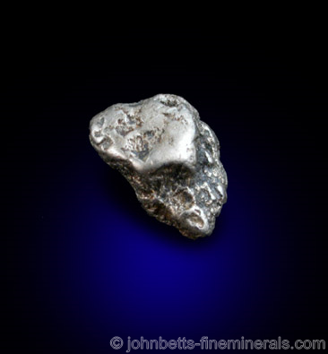 Platinum is one of the rarest minerals and metals. It has gained popularity in the use of jewelry making and is more expensive than comparable gold jewelry items.
According to Minerals.net "Platinum is rare, with few noteworthy occurrences. Russia is the most important producer of Platinum specimens, producing fine nuggets along a north-south belt along the spine of the Ural Mountains. The districts producing the largest specimens are Nizhniy-Tagil in Sverdlovsk Oblast; and the Is River in Perm Kraj. In far-east Russia, the Konder Massif near Nekl'kan, in Khabarovskiy Kraj is especially known for its exceptional cubic and twinned crystals. Two other Russian Platinum localities are the Talnakh District, in the Norilisk District in Siberia; and Ledayanoy Ruchey, Koriak, in the Kamchatka Peninsula.The world's largest deposit of Platinum is in the Merensky Reef in the Bushveld Complex, South Africa, though few specimens from South Africa ever make it to the mineral market. Colombia has produced fine placer nuggets in Choco Department, in the San Juan and Atrato Rivers near Papayan. In Australia, Platinum nuggets have been found in the Fifield District of Cunningham and Kennedy Counties, New South Wales.In the U.S., the only commercially producing Platinum mines are in the Stillwater Complex in Stillwater, Sweetwater, and Park Counties, Montana (specifically at the Stillwater Mine near Nye, and the East Boulder Mine, south of McLeod). Alaska has produced Platinum nuggets in a few placer deposits, and those from the Salmon River in Goodnews Bay (especially at Fox Gulch) have made their way to collections. Platinum also is found in the placer deposits of Trinity Co., California. Another U.S. locality is Cape Blanco, Curry Co., Oregon.The only active Platinum mine in Canada is the Lac des Iles Mine, near Thunder Bay, Ontario, which is mined primarily for palladium. In British Columbia, small nuggets come from the Tulameen and Similkameen Rivers and their tributaries near Princeton. - See more at: http://www.minerals.net/mineral/platinum.aspx#sthash.c82VgNzQ.dpuf"
#1 - Platinum
#2 - Turquoise
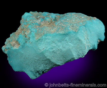
Turquoise is the birthstone for December which is not only the beginning of winter but also my wife's birthday. It is also a mineral commonly used in "Native American" jewelry.
According to Minerals.net...
The Mineral turquoise |
Turquoise is an antique ornamental stone, highly regarded for its unique and striking namesake color. Valued in both the ancient Persian and Native American civilizations, it still retains its popularity today. Turquoise specimens are often polished or sliced for collectors, and may even be dyed. Turquoise is porous and has a naturally waxy luster; it is sometimes impregnated with a plastic lubricant for to enhance its luster and increase its stability. Many Turquoise fakes exist. The most prevalent is white Howlite dyed blue to resemble Turquoise.
Turquoise often contains embedded shiny Pyrite flakes, or may contain black oxide veins running through it. It is sometimes intergrown together with other secondary copper materials, especially Chrysocolla. Turquoise may also form as a pseudomorph of other minerals such as Apatite, Beryl, and feldspars.
- See more at: http://www.minerals.net/mineral/turquoise.aspx#sthash.HIqzJH2V.dpuf
Turquoise often contains embedded shiny Pyrite flakes, or may contain black oxide veins running through it. It is sometimes intergrown together with other secondary copper materials, especially Chrysocolla. Turquoise may also form as a pseudomorph of other minerals such as Apatite, Beryl, and feldspars.
Types of Maps
Choropleth Map

Choropleth Map - Wikipedia defines this map as a "a thematic map in which areas are shaded or patterned in proportion to the measurement of the statistical variable being displayed on the map, such as population density or per-capita income."
Dot Map
 | ||||
Isarithmic Map
Proportional Symbol Map
|


Stone Mountain Topographic Map

Stone Mountain with elevations in 100 feet increments from 900 feet - 1,600 feet.
Subscribe to:
Posts (Atom)